
Tower and Town, August 2020 (view the full edition) (view the full edition)A Virtual Tour Through Marlborough (Part 1)I would like to start my tour at the end of Tin Pit Lane, which was given its name because there used to be a corporation rubbish dump there. Tin Pit Lane is off St Martins which gets its name from the chapel of St Martin which stood at the bottom of Cold Harbour Lane from 1254 until 1549. The name Cold Harbour suggests a building where travellers could find shelter for the night. The end of Tin Pit Lane becomes a footpath and overlooks on the right hand side the valley of the River Og. Across this valley is a bank which used to contain a pond which supplied fish to the castle in medieval times. Tin Pit Lane comes out onto the edge of The Acres housing estate built by Marlborough Borough in the late 60s & 70s. The roads are named after burgesses of the Borough who owned strips of lane for agriculture in the 17th century. The five roads include one named after Thomas Baylie who owned the Merchant's House in the High Street. Also on The Acres is Rogers Meadow named after Sgt Maurice Rogers of the Wiltshire Regiment who lived in St John's Close and was awarded a posthumous VC at Anzio in 1944. Walking up the footpath from the end of Tin Pit you come to the top of Blowhorn Street, so named because the Corporation herdsman used to walk up here blowing his horn to alert the burgesses to look to their cattle grazing on the Common. Another road crossed is Chiminage Close named after the chiminage tax which is a toll that used to be paid by townspeople for passing through the forest. Robert Somerfiled (Mayor in 1477) gave this land to the town so the income could pay these tolls. The Borough built Marlboroughs first council houses, Chiminage Close, on this land from 1912 to 1923. Across from Chiminage Close is Piper's Piece which borders onto Herd Street, so named because the burgesses drove their livestock up here to graze on the Common. Pipers Piece, comprising eight unusual and interesting houses, was the first modern spec development in the town in the 1930s and named after the building company of Piper & Sons. Across Herd Street, St David's Way leads into Kingsbury Terrace, an attractive row of twelve cottages with pedestrian access only, which in turn leads onto Kingsbury Street. This street used to be the boundary between St Mary's and St Peter's parishes and also a ward of the medieval borough. Almost opposite Kingsbury Terrace is Blackwall Footpath with a brick wall which has been tarred for protection. This footpath leads to Back Lane which is parallel to the High Street and originated from one of the terraces stretching east/west and from the River Kennet to the Common. There are several alleyways leading from Back Lane to the High Street and from east to west they are Ironmonger Lane, Chandler's Yard, Halfpenny Lane and Castle and Ball Yard. On the first two of these alleyways there are kinks which are on the line of the earliest east/west road through Marlborough. This came in from St Martins, along Silverless Street (the Boroughs Jewish quarter), headed west and across Hyde Lane. 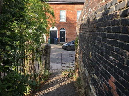 Blackwall Footpath It was down these alleyways that the besieging royalist army came during the siege of Marlborough in January 1642 to capture the town which was held for Parliament. One of these alleys, Chandler's Yard, used to be called Horsepassage Lane and that name commemorated the event. The present name is from my great great grandfather, Thomas Chandler, who owned the saddlery shop on the High Street in the late 1800s which is now the White Horse Bookshop. David Chandler |