
Tower and Town, August 2024 (view the full edition) (view the full edition)Prehistoric Treacle BollyTreacle Bolly, located to the south west of Marlborough, has an interesting story to tell. The steep strip of downland, also known as Granham Hill, has escaped the plough thus preserving many archaeological features. This, the first of two articles, focuses on Prehistoric Treacle Bolly and locations for specific sites are given using What3Words (e.g random.three.words) The earliest evidence for people living in Treacle Bolly is through a Mesolithic (9,600 - 4,000 BC) flint scatter (left behind from people making flint tools) found in the field just at the top of Granham Hill (loved.hydration.suave). The landscape would have been more wooded in the Mesolithic and large animals such as wolves, bears and aurochs would have been hunted. Skip forward in time to the Neolithic (3,400 - 2,400 BC) and the landscape would have been different. The woodland would have been much reduced and people were beginning to build large monuments. Located just to the right of the footpath to Granham Farm (surfed.layers.fidelity), an earthen long barrow was constructed (although this is disputed). The feature is substantial, measuring 76 metres long, 13 metres wide and between 2.3 and 3.1 meters high. Although modern ploughing, a holloway and the construction of the Wansdyke have damaged the mound, it is easily discernible under the trees. Towards the end of the Neolithic, the nearby Marlborough Mound was constructed (approximately 2,400 BC). Although smaller than Silbury Hill, the Marlborough Mound is similar in that their purpose is unknown. It is tempting to speculate it may have had a relationship with the long barrow. Another feature which is common in prehistoric landscapes is standing stones, and a lone sarsen stone can be found in Treacle Bolly (circus.conjured.campers). Bearing an inscription to George Charles Bell, who was a Master at Marlborough College, the location of the inscription on a stone halfway up a hill and away from the main path, suggests that the inscription was added later to an already extant stone. Adjacent to the long barrow and recorded on the 1900 OS Map as a British Settlement, various earthworks, which may indicate a settlement dating from the Iron Age, can be located with ease (credit.deleting.invested). However, a brief examination of the landscape indicates that the earthworks may be from different time periods and possibly not be all settlement traces. This may explain why on the later map published in 1923, the earthworks, roads and quarries are shown but the label has been omitted. These earthworks will be explored further in the next article 'Historic Treacle Bolly'. 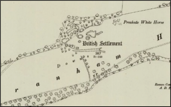
https://maps.nls.uk/os/25inch-england-and-wales/ But tantalisingly, it may be that this settlement gave rise to the unusual name of Treacle Bolly. Although extreme caution must be exercised when interpreting place names, Treacle Bolly may mean Bolly's settlement on the hill, or in a narrow valley or by a wood or spring. Before the Roman Invasion, the language spoken in Britain was Brittonic and would have been similar to modern day Welsh and Cornish. If the place name is broken down into Tre and Cle, then further clues can be found. Tre means settlement and is usually found as a prefix to place names. Cle which could be: 1) Cle - cliff, an escarpment, a hill-slope or a river-bank 2) Cul - a narrow valley or 3) Col - meaning spring or wood. It is a challenge as all of the possible place names fit the landscape! Brittonic place names in Wiltshire are more common than you might think: Pen = hill, Dun = the Downs, also meaning hill, Cwm = coombe and Afon = river. It is very exciting to think that Treacle Bolly might be a 2,000 year old survival of a place name. This is just a brief, tip-of-the-iceberg analysis of the prehistory of Treacle Bolly and indeed of Marlborough. The next article will focus on historic Treacle Bolly. Sources: 1 https://www.heritagegateway.org.uk /Gateway/Results_Single.aspx?uid=220612&resourceID=19191 2 https://www.marlboroughmoundtrust.org/ 3 The use of Gothic Script on an OS map tends to be used to denote Prehistoric activity before AD43 4 https://salisburymuseum.wordpress.com /tag/place-names/ Kim Wakeham |